POOLE HARBOUR, POOLE
Dorset, England
Index: A B C D E F G H I J K L M N O P Q R S T U V W X Y Z
 
 Click here for more information


Poole Harbour, Dorset, England         OS Map Grid Ref: SZ005890
 The County of Dorset
MAPS
FROM
MULTIMAP
1:100,000     Photo
1:200,000       Photo
1:500,000       Photo
www.streetmap.co.uk


1   HITS ON THIS PAGE THIS YEAR

 Shopping Centres    Leisure Centres    Theatres    Country Parks    Churches    Information Centres    Accomodation    Caravan Sites    Camp Sites    Historic Houses    Gardens    Ancient Monuments  

Notice Boards

Community
1   message
Events
Wanted & Lost

Poole, Dorset

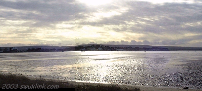
This huge inlet of the sea measures some 7 miles from north to south and about half that from east to west but, so irregular are the shores of the inlet that they extend over a hundred miles.

Looking across Pooole Harbour from Canford Cliffs towards Brownsea Island with the hills of the Isle of Purbeck beyond on a December evening.

If the drainage system of county of Dorset is subdued and not reknowned for any large bodies of water then Poole Harbour by its sheer extent and the intricacy of its shore more than makes up for the ommission. At the seaward end, the harbour is almost enclosed save for a narrow channel crossed by a car ferry by Sandbanks and the Studland peninsula. This large and nearly enclosed body of calm water which is subject to the double tides which prevail in Bournemouth Bay has been dubbed The Lake of Dorset.

It is to this peculiar phenomemon of the double tide - for it is subjected to two tides every twelve hours with about three hours between successive high water - that the harbour owes much of its beauty. It retains much of its load of water and does not suffer the low tides which expose vast expanses of barren mudflats in other estuaries and harbours.

Tide Predictions Admiralty Charts & Publications

ISLANDS IN POOLE HARBOUR

Adding to the interest and charm of the harbour with its convoluted shore are its many islands and Brownsea near its mouth, the largest, most conspicious and best-known of these, deserves seperate consideration.

Among the larger islands in the harbour (Brownsea, the largest, being mentioned separately) are Round Island, Long Island, Green Island and Furzey Island.

In June 2002, it was announced that sole use of Green Island which is in private hands could be obtained on payment of a rent of £ 1,000 annually to the owners.


Managing the Harbour

The port and harbour have been managed since 1895 by the Poole Harbour Commissioners who are a statutory body established by Act of Parliament. Their aim is to maintain the harbour as a commercially viable port so as to finance improvements and conservation. The Commissioners have to balance recreation, fishing and economical interests as well as commercial ones.

The Poole Harbour Commissioners are charged with the conservation, regulation and improvement of the Harbour environment. In evolving their policies, consultation with many local bodies is involved, including Poole Borough Council, Purbeck District Council, Dorset County Council, English Nature, the Environment Agency, the Ministry of Agriculture, Fisheries & Food and the Southern Sea Fisheries Committee. The Commissioners also have close working relationships with other interested parties such as the Harbour yacht clubs.


History of the Harbour

The harbour, on the site of the Great Solent River which flowed eastwards acrosss the area, has been formed since the last Ice Age when the sea broke through the ridge of chalk which connected the Old Harry Rocks to The Needles on the Isle of Wight.

It is believed that rising sea levels have caused the waters of the harbour to rise and drown the evidence of pre-Iron Age human settlement and activity around the shores of the harbour. The shores of the harbour were settled by the Durotriges from Northern Europe, as is evidenced by the shards of their characteristic brown and black pottery which have been found throughout the area. Hengistbury Head to the east was an important Iron-Age settlement and port and was thought to be the premier port of the Iron-Age British Ises until the discovery of a huge port complex in Poole Harbour in 2002. The harbour seems to have been a center for the import of Roman luxury goods from Continental Europe.


WILDLIFE

The waters and mudflats on the shores of the harbour attract many waders wildfowl which over-winter in the harbour and many of which roost here throughout the year. The area to the south and west of the harbour has not only been designated as an Area of Outstanding Natural Beauty but many of the heathlands there are Sites of Special Scientific Interest (SSI's) and harbour, among other fascinating species and habitats, all six species of reptiles native to the British Isles

OYSTERS
Ostrea edulis

The waters betweem Poole Harbour and Chichester Harbour to the east are the principal breeding-ground of our native oyster, Ostrea edulis. Ownership of selected areas of oyster fattenings (known as 'layings'), including those within Poole Harbour, is controlled by the Southern Sea Fisheries District. The unwitting delicay fattens for three years before being harvested and sent to the retaurant table - usually abroad.

THE SURROUNDING AREA

The area which surrounds the island and mudbank speckled waters of the harbour to the south and west is comaratively unspoilt and has been designated an Area of Outstanding Natural Beauty.

To the east of the harbour mouth the sandy spit known as Sandbanks is, at its narrowest, only a few hundred metres wide although it broadens out towards its extremity. It is populated with presitious houses and apartments and the clean sandy beaches are a mass of colour during the holiday season.

But minutes' ride on the ferry across the harbour mouth brings the wilder beauties of heath, marsh, sand-dunes and qieter beaches as one disembarks on the Studland peninsula owned by the National Trust. Inland, as the widening strip of land joins the Purbeck hills lies the pretty village of Studland itself which might be missed amongst its many trees.

On the western shores of the harbour, Russell Quay has a large heronry and Ower has an interesting pond much frequented by seagulls. The picturesque village of Arne boasts a tiny church as its only amenity but is also host to the Arne RSPB reserve. Wyche once served as port to the villagers of Corfe and the masters of the castle there. Now it is but a few houses. Perhaps its greatest claim to fame (at least within the local area) is the oil which is surrendered by the rocks deep beneath trunk and turf and the controversey which the discovery of the black gold sparked.

The heathlands which are found here on the southern and western shores of the harbour such as on the Studland peninsula, at Agglestone and Arne make an ideal habitat for our reptiles. So much so that all six reptiles native to the British Isles are found there. Many of these heathlands have been designated as Sites of Special Scientific Interest (SSI's).

BibliographyDiscuss this PageHits on this PageLegals
Locally
Links

Links to Other Pages on this Site

TOWN OF POOLE
Port of Poole
Poole Harbour Commissioners
Poole Harbour Heritage Committee

DORSET
The Wessex Newfoundland Society

Crash-landing of Portland Sea Rescue Helicopter (July 2002)
DORSET
  Towns & Villages of Dorset
 

Links to Other Sites

. . . . . the inclusion of these links to other sites is for the interest and convenience of visitors to this site only and does not imply any endorsement of the products or services offered by the individuals or organisations involved nor the accuracy of the information contained therein . . . . .


BibliographyDiscuss this PageHits on this PageLegals
Links
Locally

Links to Other Pages on this Site

TOWNS & VILLAGES
Arne
  Isle of Purbeck, Dorset, England
3.1 km SE
Brownsea
  Dorset, England
1.8 km SW
Canford Cliffs
  Dorset, England
5 km NW
Hamworthy
  Dorset, England
2.9 km NE
Parkstone
  Dorset, England
4.7 km NW
Poole
  Dorset, England
1.5 km NW
Tuckton
  Bournemouth, Dorset, England
1.1 km NE

OTHER PLACES
Alfreds Tower
  Wiltshire, England
52.8 km NE
Old sarum
  Wiltshire, England
46 km NW
Salisbury Cathedral
  Salisbury, Wiltshire, England
42.8 km NW
Stonehenge
  Wiltshire, England
54.3 km NW
Wilton Windmill
  nr. Wilton, Wiltshire, England
77.1 km NW
Woodhenge
  Wiltshire, England
56.3 km NW
Tan Hill
  Wiltshire, England
75.8 km NW

POOLE
POOLE HARBOUR
  POOLE HARBOUR COMMISSIONERS
PORT OF POOLE
BROWNSEA ISLAND
BOURNEMOUTH
WAREHAM
 

Discuss this PageHits on this PageLegalsLinksLocally
Bibliography

Recommend a Book for this Page

The Story of Poole, Old Town, Port & Harbour
Joan Sutton ©1988   ISBN 0 906596 04 1

BibliographyDiscuss this PageHits on this PageLegals
Links

BibliographyDiscuss this PageLegalsLinksLocally
Hits on this Page
Hits on this page since December 6th

Jan
Feb
Mar
Apr
May
Jun
Jul
Aug
Sep
Oct
Nov
Dec

current year: previous year:

 Home Page  Useful National Web Links  Back: Display Previous Frame  Show Page Title Bar  Resize Window: 800x600 Resize Window: 1024x768
 
Managing the Harbour
History

Local Site Map
Islands in the Harbour
The Surroundings

 Formation of the Harbour
 20thCentury
 Beating the Bounds
 The Port of Poole
Wildlife

Links
Locally
Bibliography


 Click here for more information
 Close this Menu Panel
ALPHABETICAL
SITE INDEX
Select ;-

Aa-Az   Ba-Bz   Ca-Cz   Da-Dz   Ea-Ez   Fa-Fz   Ga-Gz   Ha-Hz   Ia-Iz   Ja-Jz   Ka-Kz   La-Lz   Ma-Mz   Na-Nz   Oa-Oz   Pa-Pz   Qa-Qz   Ra-Rz   Sa-Sz   Ta-Tz   Ua-Uz   Va-Vz   Wa-Wz   Ya-Yz   
SW COUNTIES
BibliographyHits on this PageLegalsLinksLocally
Discuss this Page

No messages posted on this page

Only Members of the Site can post messages in this section. Signing in is easy from our Home Page.

BibliographyDiscuss this PageHits on this PageLinks
Locally
Legals

DISCLAIMER: Whilst we endeavour to ensure the content of this site is correct, we cannot undertake that information you find here, is, or will remain accurate and complete. We do not warrant that any information contained on this site is fit for any purpose. If you wish to place reliance on any such information you must check its accuracy by some other means before doing so.

MEMBERS get aditional features on our pages and will soon be able to interact with the site and add their views and informastion. Sign up, from the Home-Page, is simple and involves typing in your email address and a password of your choice.

If you are in any way connected with any location or interested in the subject mentioned on this page and have an hour or two a month to spare, we would welcome you as a local moderator - please email the webmaster by CLICKING HERE.

Privacy Policy

last updated on
Copyright © 2000-2003 swukink.com
page ref: BAAAGBSR

Commercial Building / Office building|