823 HITS ON THIS PAGE THIS YEAR           
 | | Notice Boards |
A small market town in the north-east corner of Wiltshire near the Oxfordshire border, five miles to the north-east of Swindon on the A361 Lechlade road.
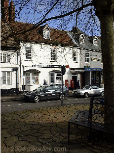
Post Office in Sheep Street
At an elevation of four hundred feet, the town derives its name its position as 'High Enclosure' or 'Homestead' and has in ancient times been called "Vorda", "Worth" and "Wrde". Until the GWR established its workshops at New Swindon, Highworth was larger. To the east is the Cole valley while to the north-west is the valley of the river Thames with the Cotswolds beyond.
BLANDFORD PASSAGE
BULL INN
BUSH HOUSE
CHANTRY COTTAGE, Lechlade Road
CHURCH HOUSE
CIVIL WAR
CORNER HOUSE, LechladeRoad
FAIRS
FISH STEW
GLOUCESTER HOUSE
GREAT PLAGUE 1664-5
HIGH STREET
HIGHWORTH HOUSE, LechladeRoad
HISTORY
HOME FARM, LechladeRoad (site of)
INIGO HOUSE, High Street
IRON AGE
JESMOND HOUSE, LechladeRoad
KING & QUEEN INN
LECHLADE ROAD
LLOYDS BANK
MARKET
PLACE
MANOR HOUSE, High Street
NORMAN
| |
OLD MONASTERY, High Street
PARISH CHURCH
PEOPLE
POUND LANE
PLAGUE 1664-5
ROMAN
ROUSE FAMILY
SARACEN'S HEAD HOTEL
SAXON
SMALLPOX (1789-90)
SMITH, ALBERT
ST MICHEAL'S
STATION ROAD
STRANKS, MRS
TIB DAY
TUDOR
WATTS, W H
WHITE HORSE INN
WHITE HOUSE, LechladeRoad
WINDING HATCH
WOODBRIDGE FAMILY
|
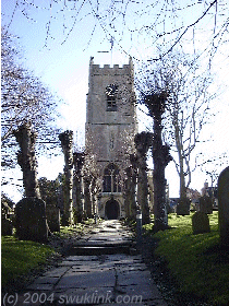
St Micheal's and All Angels Parish Church
 The only mention of the town in William the Conqueror's great 'Domesday Book
' recording land ownership and taxation values in 1086 is very brief and concerns the church; "Radalphus, the Priest, holds the church at Wrde". The record of the clergy and patrons of St Michael's dates back to 1290.
It is likely that an early Saxon church stood on the site of the present building before the Norman conquest but we know a cruciform church stood here in the 12th century. According to the late Wiltshire antiquarian CE Ponting, the east, north and south arms of the 12th century were of the same extent as the present chancel and transepts. Part of this 12th century has been retained in the walls of the present chancel and the north transept and one of the original deep window openings can still be seen in the wall to the left of the altar.
The south porch with a priest's room above was erected in the 14th century. Within the church, a squint allowing the priest see inside the church from the room above the porch can be seen high above the south door.
It is during the 15th century that most of the present church was built. The nave was rebuilt and extended and the transepts were rebuilt. The tower was added together with the chapels on the north and south sides of the chancel. Mr CE Ponting reckoned the construction to have taken place between 1440 and 1480 - during the turbulent period in English history later known as the Wars of the Roses (1455-1485) when the Houses of Lancaster and York vied for power. It is a measure of the limited effect of this series of battles without standing armies on the country as a whole that such a huge project could be undertaken (in contrast with the Civil War two hundred years later).
The parish registers date from 1539 during the reign of King Henry VIII (1509-1547) - the registers were made compulsory the previous year by his Vicar General, Thomas Cromwell.
As with many parish churches in the 19th century,
St Micheal's and All Angels underwent a "Great Restoration" in
1861-2.
website: ST MICHEAL'S AND ALL ANGELS
|
Highworth Community Church
8 Sheep Street,
Highworth,
Swindon,
Wiltshire
SN6 7AA
tel: 01793 765060
|
|
Highworth Methodist Church
Vicarage Lane,
Highworth,
Swindon,
Wiltshire
SN6 7AD
tel: 01793 764544
|
A market is held in the Market Square (used as a car park during the rest of the week) every Saturday morning.
Anyone can set up a stall in the market on payment of a small toll to the toll master. The town was always busy on Saturdays as farming families converged on Highworth to do their weekly shopping.
The picturesque High Street contains many houses dateing back to the 17th and 18th Centuries. In the latter 19th century, there were thirty-one businesses in the busy street serving not only the town but the surrounding communities.
Blandford Alley is reputed to have been an escape route for thieves working the fairs and markets.
Inigo House, with its walled garden at the rear, is one of two houses in the town reputed to have been built by the famous architect Inigo Jones.
Next door is the old post office which was the headquarters of the British Resistance during
World War II. Mrs Stranks the postmistress played a great part in this secret enterprise described in a book entitled 'The Last Ditch'.
Part of the King & Queen Inn |
The King and Queen Inn is one of Highworth's old buildings and retains the old court room at the rear where the manorial court was held. At one time it possessed two rows of stables at the rear and the yard is reputed to be haunted.
The confectionary shop next to the Inn was owned by Mr Albert Smith who sold sweets, toys and china from a stall outside the shop during fairs. The shop was also famed locally for the hot faggots and peas cooked by Mrs Smith and sold on Thursdays and Fridays.
|
The Manor House or Old Monastery at the eastern end of the High Street is reputed to be haunted by a monk who makes his way across MarketPlace and Sheep Street to St Micheal's.
The Saracen's Head Hotel was believed by local folk to have been part of a monastery. Its old oak beams are exposed in the lounge and alterations in the late 1960's revealed a confessional suporting its monastic use.
Sun Yard links the High Street with Brewery Street. The Sun Inn is reputed to have stood about thirty metres from the High Street on the left and may have been connected to the Sun Brewery a little to the east.
Winding Hatch is a narrow passage which links the High Street with the Parish church.
Located on the north side of the High Street and linking it to Sheep Street, Market Place has always been the center of activities in Highworth. In olden times there was a well in the center of the squre, reputed to be 80 feet deep, from which residents would draw there water before the advent of modern piped supplies. Nearby stood wooden troughs to water the livestock brought to market and for the use of travellers' horses.
Markets were held regularly, particularly on Saturdays when the inhabitants of the surrounding farms and villages would converge on the town for their weekly shopping and a Saturday Market continues to be held.
The main fairs were held at Michealmas and Lammas. Nowadays the fair is restricted to a funfair but before the advent of steam roundabouts, in addition to the usual produce and goods sold at the market there would be a large number of shows and booths. Other passtimes such as wrestling and boxing took place, as did plays performed by troups of itinerant actors.
As well as local inhabitants, the fairs attracted all manner of visitors such as fortune-tellers, gypsies and theives, all determined to profit from the occassion.
The second day of the fairs was known as "Tib Day" and devoted to much merry-making and drunkeness.
|
In 1871, when the town crier lived in Church House, it was a "bush house" - if a bush was hung over the door, ale could be sold during the fairs.
|
 The detached red brick building in the north-west corner of the Square, now occupied as a shop by the Sue Ryder Trust, was the old Market House where hurdles were stored after the markets. At one time it was also called the "Town Hall". The detached red brick building in the north-west corner of the Square, now occupied as a shop by the Sue Ryder Trust, was the old Market House where hurdles were stored after the markets. At one time it was also called the "Town Hall".
The Bull Inn was once in the square and preserved upon a shelf in the inn was a skull which had been excavated nearby.
| Gloucester House & Lloyds Bank | |
Known as the Globe Inn, the buildings which were partially destroyed by fire and sold to Francis Heath in 1806 by Thomas Radway. About 1832, they were purchased by Robert Jenner, a woolstapler, two dwellings and a warehouse for the wool in which he traded. It was also used as a bakery and the dwelling of the baker, William Newman. |
|  |
The road to Lechlade was a turnpike and, beyond the Plough Inn at the northern end of the town, stood the turnpike house.
Corner House
on the corner of Lechlade and Cricklade Roads is thought to date from the 12th century.
Jesmond House
near the junction of Lechlade and Cricklade Roads, is now a hotel offering fine views eastwards down the High Street. It is one of two houses in Highworth designed by Inigo Jones and the one-time home of SB Burton, an authority on the restoration of churches.
The White House
contains some panelling dating back to the reign of Queen Anne.
Highworth House
once served as the vicarage and a brewer named Hulbert lived there in the 19th century.
|
Home Farm
stood opposite the western end of St Micheal's Church on the site of
St Micheal's Avenue. It was here that Parliamentary troops assembled before their attack on the
church during the Civil War. All that remains is Home Farm Cottage and the name perpetuated in the Home Farm Estate.
|
Chantry Cottage
opposite St Micheal's Avenue is the oldest house in Highworth and may have been the residence of
Radalphus the Priest who held the church at the
time of the Domesday Survey of 1086.
Reg Skull Motors
on the corner of Station Road was formerly William's Garage. Previously the site had been a sawmill processing all manner of timber for building work and other uses.
The White Horse Inn
is the oldest in Highworth.
Off Lechlade Road, the fields were the site of claypits and brick kilns for many years and a lime house were lime was burned. Once offering fine views of the Thames Valley, the fields are now the Home Farm Estate.
| Church House, Sheep Street |
| The house was frequented by the famous actress Lilly Langtry (1853 -1929). She was noted for her great beauty and for her affair with King Edward VII rather than as a great actress and must have created quite a stir in the town on her visits. The long garden stretches to Cherry Orchard Lane and once had stabling for four horses. The Globe Brewery was also at its rear.
Four dwellings which stood on the site burnt down in 1765. Rebuilt as the "Red Lion", it was later converted into two dwellings. Around 1819 it was converted into one house and, about 1872 became the "Globe Brewery". In 1879 the house was leased to George Langtry of Park Lane, London, and ceased to be a brewery ten years later when it was occupied by a vetinary surgean and renamed "Globe House". It has been known as "Church House" since 1893.
In 1871 the town crier lived in Church House and it was a "bush house" - if a bush was hung over the door, ale could be sold during the fairs. |
| Coffin Close |
| Legend has it that a dead king or chieftan who died in ancient times was carried across Britian in a lead coffin to his final resting place. On reaching Highworth, the party were given permission to rest in a paddock in Westrop and the locals have known it as "Coffin Close" ever since.
|
| Eastrop |
| Eastrop, deriving its name from the Danish occupation of the town, starts at the eastern end of the High Street.
The tythe barn where the farmers brought a tenth of their produce for the church stood on the site of the library in Brewery Street. Parsonage Farm House was the home of Wolfe Barry whose father, Sir Charles Barry, designed Tower Bridge in London, the Barry Docks, Cardiff, and the Bristol Suspension Bridge.
On the site of the small lawn and shrubbery opposite the lodge and drive to Eastrop Grange stood the stables where Edmund Jefferies stabled the horses he used for hauling the stone produced in the local quarries. |
| Pound Lane |
| The area around Pound Lane is now a housing estate. The pound where stray livestock where impounded until the owners paid the fines and collected them was here and the road ended in a small farm. |
| Westrop Farm House |
| At one time the largest house in Highworth, the house behind its high wall was once part of the manor of Westrop. Mrs Arnold Rees discovered the old beams and there is an ancient fireplace. The pigeon loft behind the house may be even older thn the house itself and is reputed to be haunted. |
Highworth Town Council
Council Offices,
High St,
Highworth,
Swindon,
Wiltshire SN6 7AG
tel: 01793 762377
Town Clerk:
Mr David Lane -  email email
|
The hill-top site was occupied during the Iron Age when the valleys around were heavily wooded and the settlement known as
'Vorda', 'Worth' or 'Wrde'. The Britons have left scant evidence of their occupation and modern Highworth owes its foundation as a town to the Romans who established a settlement here as a military observation post overlooking the Thames valley in the third or fourth century AD.
The area around Highworth is rich in Roman remains such as Ermine Street which followed the line of the A419 at Swindon, the large station of Nidum at Nythe (where a horde of between 1,600-2,000 Roman coins was unearthed in 1689), another station at Cold Harbour, Blundson, a Roman farmhouse between Oxleaze and Lower Burytown Farms on the Blunsdon Road, two at Common Farm, Highworth, villas at Stanton and Hannington Wick.
Between twenty and thirty skeletons were unearthed in an orchard belonging to Westrop House to the north of Westhill House and were believed at the time to be the bodies of soldiers killed during the Civil War. Two more skeletons were discovered a few metres to the west in about 1909 and further excavations of the site by AD Passmore on November 6th, 1933, showed the remains to date from the
fourth century;
The mound is a long low irregular one in a corner of the paddock and appears to have been formed as much by earth taken away from around as by piling on top, in modern times it has been used as a rubbish dump from the house, under this rubbish at a depth of about 3 feet (towards the south end) the skeleton of a young girl of about 18 years was found, lying on her back with legs extended to the south, and face turned to the east, although the line of the body was generally north to south. At and slightly above the knees was a small brass Roman coin which is unfortunately undecipherable, but is no doubt of a date about the middle of the 4th Century A.D., the body was lying on clean sand while the legs rested on a flat stone; at the shoulder was a large piece of Roman pottery and many other bits were present in the soil. As other skeletons have been found here this is no doubt the burying place of a small settlement.
| | - AD Passmore |
The laying of a gas main under the footpath between Westhill House and the road in 1973 revealed a number of shards of Roman pottery and large numbers of fragments have been found to the north of the footpath running past the cemetery.
Roman pottery has been found during the construction of houses at Wrde Hill and the remains of a Roman soldier were
uncovered in a garden in Oak Drive suggesting that there may have been a military outpost here. Aerial photographs suggest that there may be two Roman buildings on Common Farm just east of the town.
see also: Roman Wiltshire
Following the departure of the Romans in 410 AD and, in time, the area was invaded by the Saxons. Shunning the marshy ground towards the north, they probably farmed the drier land to the south of the town and probably built the first church at Highworth. A small structure, parts of it are probably incorporated into the present church. They also enclosed the town for defense against the marauding Danes as well as rival Saxon kingdoms. It is these defenses which are alluded to in the name, 'Highworth', meaning 'walled enclosure'.
The town, atop its hill, was captured by the Danes who are thought to have destroyed many of the Saxon buildings. The memory of their occupation is preserved in the Norse names 'Eastrop' and 'Westrop'. A number of great battles between the kingodm of Wessex took place in 871, most won by the Norsemen until they were decisively defeated by king Alfred the Great towards the end of the year and Highworth was returned to Wessex. There followed a period of comparative peace and prosperity until the country was thrown into a turmoil on the murder of King Edward in 979 from which it didn't fully recover until the Norman invasion of 1066.
William the Conqueror ordered the compilation of the 'Domesday Book ', a register recording land ownership and taxation values, in 1086. The mention of Highworth is very brief; "Radalphus, the Priest, holds the church at Wrde". Although there are very few records of Highworth during the reigns of the Norman kings (1066-1154), much of the land in the area, and particularly around Sevenhampton, was in the possession of the Earl of Eu who had accompanied Duke William on the conquest.
|
It is believed that this "Radalphus, the Priest" lived in what is now known as "Chantry Cottage" in Lechlade Road to the north of the War Memmorial, one of the oldest in the town and once possessed of a thatched roof.
|
In 1378, John de Montford was compensated for the surrender of the castle of Brest in France with lands at Castle Rising in Norfolk and Sevenhampton. In that year, the Wiltshire estates were at farm to the former steward of Edward, Prince of Wales, for 160 marks.
The reversion of Sevenhampton manor and the hundreds of Highworth and Cricklade was granted to Edmund, Duke of York, in 1391. Six years later, the Duke recieved these properties for life and it seems that the property was inherited by his son Edward who is found dealing with it in 1415. In 1461, Highworth was included in the lands granted to Cicely, Duchess of York and mother of Edward IV.
Henry VII (1485-1509) granted Cricklade, Highworth and Sevenhampton to his wife Elizabeth in 1492 for her maintenance during his proposed invasion of France. The lands passed to Catherine of Aragon on her marriage to King Henry VIII (1509-1547) in 1509 and probably to Jane Seymour in 1536. The property was granted to Anne of Cleves in 1539, before her marriage to the king in 1541 while it only came into the possession of Catherine Howard later that year when she was already queen.
In 1541, the estates, together with nearby properties of the recently-dissolved monasteries, were granted to Sir Thomas Seymour (c.1508 - 1549) ending some two and a half centuries of possession by the Crown.
|
Seymour immediately obtained a licence to alienate the site of the former house and its appurtenant buildings, 1,520 acres of arable land, demesne pasture adjacent to the site, a meadow called Chillade and an enclosed pasture called Billingham to Sir John Brydges of Cubberly in Gloucestershire who already held all of these on lease at an annual rent of £16 13s 4d.
|
|
Under a similar licence in 1542, all the customary rents and services (which amounted to £2 6s 8d and 2lb of pepper) owned by Seymour for the chief mansion called Warneford Place and a number of closes were sold to John Warneford for £278.
|
|
The Warneford family (who are thought to have taken their name from Wranford in Hampshire) had been established at Sevenhampton since at least 1393. They had built up a considerable estate by the mid-16th century but this is largely undocumented.
|
The boroughs of Cricklade and Highworth remained in the possession of the Crown until 1544 when they were granted with the hundreds of Cricklade, Highworth and Staple to Catherine Parr for life as part of her dower. In 1547, the reversion was granted to Seymour who married the widowed queen. Having unsuccessfully attempted to oust his brother Edward, Lord Protector, and seize the crown, Seymour was attained and executed at the Tower of London on March 20th, 1549 for treason and his estates, including the boroughs of Cricklade and Highworth, reverted to the Crown.
The Warneford family continued to accumulate property in and around Highworth.
In 1633, Edmund Warneford purchased property to the value of £2,300 from William Bennett the younger and when Sir Edmund Warneford purchased Billingham from Sir John Yate 1685 for £1,750, he owned the whole of the manor of Highworth as it existed in 1541.
The parish church was a Royalist garrison during the Civil War (1640-1645) and was attacked by the Parliamentarians although there are scant local records of the time. The church became a Royalist garrison in December 1644. Parliamentary forces arrived at nearby Lechlade on Thursday, June 26th, 1645 and were involved in a number of skirmishes with the King's supporters. The next day they drew up before the fortified church and, Major Hen refusing to yield, attacked it. A parley which followed resulted in the surrender of seventy Royalist soldiers and eighty weapons.
|
In Joshua Sprigge's England's Recovery published in 1647 and detailing the movements of Parliamentary forces, it is recorded that after the battle "The soldiers had good booty in the church . . . " but no more details are given.
|
With its commanding view over the surrounding countryside, particularly the Thames valley to the north, and convenience to other Parliamentary garrisons such as Malmesbury, the town was ordered to be garrisoned by general Fairfax. A skirmish took place near the town in July with several skirmishers killed. They are believed to have been buried in a field to the west of the church where a large number of skeletons were reported to have been dug up in the mid-19th century.
On the surrender of Oxford and Faringdon on June 20th, 1646, Royalist soldiers in Wiltshire who had been taken prisoner were released and allowed to return to their homes.
|
In his Highworth and Round About published in 1973, PJ Archer writes that the Parliamentary soldiers occupying Highworth were very rude to visitors to Highworth's markets causing them to resort instead to Swindon which subsequently took much of the town's trade.
|
One of the cannon balls used in the battle hangs in the Warneford Chapel. Recovered from the tower of the church, the cannon ball was fixed at the apex of the roof the Grammar School before being placed in the Warneford Chapel.
|
. . . probably the Cromwellians almost destroyed the old chancel and perhaps burnt the original roof. I wonder whether this made the royal garrison surrender, because Cromwell did not hesitate to burn any building to gain victory. |
- PJ Archer, Highworth and Round About, 1973.
|
1664-5 saw the West Country ravaged by the Great Plague and Highworth suffered particularly heavily. Market towns were hard hit when plague erupted as, fearful for their lives, the visitors on whom they relied for trade would avoid them any the folk of the countryside would shop at Swindon which was not hit as badly. The town remained virtually static for a long period before it recovered.
|
Local tradition has it that the plague was carried to Highworth from London by a locally family who had delivered cattle there and that their cottages were burnt down.
|
Pestilence again struck Highworth in the form of smallpox in 1789-90 which claimed the lives of eighty-eight of the townsfolk. The whole town was inoculated with a precursor of the vaccination used by Benjamin Jesty at Yetminster but whose discovery was later credited to Dr Jenner in 1796.
The smallpox outbreak prompted the building of a Pest House between Botany Farm and the Swindon Road. Isolated from the community, those suffering from infectious diseases were cared for there by volunteers.
Mr E Elwell and Mr Booth uncovered the fish stew behind the monastery used by the monks to keep their fish. this was filled in again at the insistence of the owner ofthe land.
| |
Behind the former grocers opposite the King and Queen Inn candles and rush lights were manufactured for the inhabitants of the town and surrounding villages in the 19th century. Bakers sold jewellery and made clocks and watches. Manyof their clocks can still be seen around Wiltshire.
The former Cross Keys public house in the High Street was previously the town's post office.
Located on the north side of the High Street, Market Place has always
been the center of activities in Highworth.
SB Burton, an authority on the restoration of churches, lived in Jesmond House in LechladeRoad.
Rev. Edward Roden died in 1869, having been vicar of St Micheal's for 64 Years. The window at the west end of the north side of the church was given in memory of his wife and daughter.
The Rouse family were based at the eastern end of the High Street
manufactured ropes to supply, with many other goods, to local farmers. They also manufactured
fancy goods by straw plaiting.
Mrs Stranks, the postmistress at the old post office in the High Street during World War II, played a major part in the British Resistance which was headquartered in the building.
WH Watts, the proprietor of the tobacco and sweet shop in the High Street just west of Sun Yard was also the town's bandmaster for many years androbably a founder member of the band.
The Woodbridges were harness-makers based in the High Street. Bill Woodbridge was a keen sportsman, as was his son Ernest who carried on the business after him. Ernest also organised many events in the town such as flower shows. The business was continued by his son Bernard.
| Secondary Schools |
| Highworth Warneford School |
| Shrivenham Rd, Highworth, Swindon, Wiltshire SN6 7BZ
tel: 01793 762426 |
| | Headteacher: Mr John Saunders
A community school for boys and girls aged between 11 and 16 years with over nine hundred pupils.
Click here for the school's web-site |
| Primary Schools |
| Eastrop County Infants School |
| Eastrop, Highworth, Swindon, Wiltshire SN6 7AP
tel: 01793 763772 |
| | |
| Highworth Westrop County Primary School |
| Newburgh Place, Highworth, Swindon, Wiltshire SN6 7DN
tel: 01793 762897 |
| | |
| Northview County Primary School |
| Haresfield, Highworth, Swindon, Wiltshire SN6 7PQ
tel: 01793 765408 |
| | |
| 1275 | | A thief at Highworth, Wilts. sentenced to hanging fro stealing gold sovereigns
He wasprobably hanged at the fair as was the cistom of the time | | | | 1290 | | Earliest extant records ofclergy and patrons of St Micheal\'s Parish Church in Highworth, Wiltshire | | paris | | 1391 | | Reversion of Sevenhampton manor and the hundreds of Highworth and Cricklade in Wiltshire granted to Edmund, Duke of York | | BAAAGDAF BAAAGEEL | | by 1393 | | Warneford family become established at Sevenhampton, Wilts. | | BAAAGEEL | | 1397 | | Reversion of Sevenhampton manor and the hundreds of Highworth and Cricklade in Wiltshire granted to Edmund, Duke of York for life | | BAAAGDAF BAAAGEEL | | 1415 | | Edward, son of Edmund, Duke of York, recorded dealing with Highworth, Wilts. so he probably inherited his father\'s property in Sevenhampton manor and the hundreds of Cricklade as well | | BAAAGDAF BAAAGEEL | | 1461 | | Highworth,Wilts. included in the lands granted to Cicely, Duchess of York and mother of Edward IV
| | | | 1492 | | Henry VII granted Cricklade, Highworth and Sevenhampton in Wilts. to his wife Elizabeth for her maintenance during his proposed invasion of France | | BAAAGBRG BAAAGDAF BAAAGEEL | | 1509.Jun.11+ | | Cricklade, Highworth and Sevenhampton pass to Catherine of Aragon on her marriage to King Henry VIII | | BAAAGDAF BAAAGCDB BAAAGEEL | | 1536.May.30+ | | Cricklade, Highworth and Sevenhampton in Wilts. probably passed to Jane Seymour on her marriage to King Henry VIII (1509-1547) | | BAAAGDAF BAAAGDGG BAAAGEEL | | 1539 | | Cricklade, Highworth and Sevenhampton pass to Anne of Cleves before her marriage to King Henry VIII in 1541 | | BAAAGDAF BAAAGEEL BAAAGEKY | | 1539 | | Earliest records in the parish registers of Highworth, Wilts. | | paris | | 1541 | | Cricklade, Highworth and Sevenhampton pass to King Henry VIII\\\'s wife Catherine Howard | | BAAAGDAF BAAAGEEL BAAAGEKZ | | 1541 | | Cricklade, Highworth and Sevenhampton granted to Sir Thomas Seymour ending some two and a half centuries of possession by the Crown | | BAAAGDAF BAAAGDGD BAAAGEEL | | 1549.Mar.20 | | Execution of Sir Thomas Seymour at the Tower of London for treason
His execution brings disgrace upon Edward Seymour who was replaced as Lord Protector by John Dudley | | BAAAGDGD BAAAGBZE BAAAGDKN BAAAGDGQ BAAAGDGR BAAAGDGI | | 1624 | | Thomas Warneford made steward of the boroughs of Cricklade and Highworth, Wilts. | | BAAAGDAF | | 1644.Dec | | St Micheal\'s parish church, Highworth, Wilts., garrisoned by Rpoyalist forces | | paris | | 1645.Jun.26 | | Parliamentary forces reach Lechlade where they are involved in several skirmishes with the enemy | | | | 1645.Jun.27 | | Parliamentary forces attack the Royalists garrisoned in St Micheal\'s parish church, Highworth, Wilts. | | paris | | 1646.Jun.24 | | Surrender of Oxford and Faringdon to Parliamentary forces (Fairfax and Cromwell) effectively ends the Civil War
]]or 20th ???[[ Cromwell uses his influence in favor of granting lenient terms
Following the surrender, Royalist forces held prisoner in Wiltshire were released and allowed to return to their homes | | BAAAGCDL BAAAGEFZ BAAAGCAP | | 1664 | | West Country ravaged by the Great Plague | | BAAAGBHZ BAAAGDFZ BAAAGBFZ | | 1789 | | Small pox outbreak at Highworth, Wilts. | | BAAAGCHQ | | 1861 | | Great Restoration of the parish church at Highworth, Wilts. commenced | | paris | | 1869 | | Death of the Rev. Edward Roden, vicar of Highworth, Wilts., for 64 years | | paris | | 1890 | | A number of skeletons dating from the 3rd or 4th centuries discovered in an orchard on the north side of Westhill House, Highworth, Wilts. | | BAAAGCHV | | 1933.Nov.06 | | AD Passmore excavates the remains of a girl from the mid-4th century at Highworth, Wilts. | | | | 1990.Oct.13 | | Highworth, Swindon, twinned with Pontorson in Normandy | | BAAAGBKX | | 1994 | | Refurnishing of the Warneford Chapel at St Micheals Highworth, Wilts. | | paris |
|
| | | Links to Other Pages on This Site
|
| |
| | |
|
| | | Links to Other Sites
|
| |
| | |
|
| | | Links to Other Pages on this Site
| | | TOWNS & VILLAGES | | Kingsdown
Swindon, Wiltshire, England | 5.2 km SE | | Penhill
Swindon, Wiltshire, England | 6.3 km SE | | Pinehurst
Swindon,
Wiltshire, England | 7.2 km SE | | Stratton St Margaret
Swindon, Wiltshire,
England | 5.8 km SE | | Upper Stratton
Swindon, Wiltshire, England | 5.8 km SE | | Rodbourne Cheney
Swindon, Wiltshire, England | 8.1 km SE | | South Marston
Old Town Museum and Art Gallery, Wiltshire, Engla | 4.7 km SE | | Shrivenham
Wiltshire, England | 5.3 km SW | | | | | OTHER PLACES | | Old Town Museum and Art Gallery
Bath Road, Old Town, Swindon, Wiltshire SN1 4BA
Museum of local history; industry and art gallery. | 9 km SW | | Cricklade Museum
Calcutt Street, Cricklade, Swindon, Wilts. SN6 6BB
The collection represents the towns social history from Roman to modern times, and includes a large number of maps, photographs, and archives. | 10.1 km NW | | Cricklade Museum
Calcutt Street, Cricklade, Swindon, Wilts. SN6 6BB
The collection represents the towns social history from Roman to modern times, and includes a large number of maps, photographs, and archives. | 10.1 km NW | | Coate Stone Circle
Coate,
Swindon, Wiltshire, England | 10.2 km SW | | Coate Water
Country Park
Swindon, Wiltshire, England
Built
as a reservior to supply the Berks and Wilts Canal, Cote Water was inhabitted in
the Stone Age | 10.7 km SW | | Lydiard
Park & House
Swindon, Wiltshire, England | 12.6 km SW | | Science Museum Wroughton
Wroughton Airfield, Swindon, Wiltshire SN4 9NS
The Science Museums large exhibits including aircraft are stored and displayed at Wroughton | 12.7 km SW | | | | | Camping Sites | | Blackland Leisure Ltd
Stockley Lane, Calne, Wiltshire SN11 0NQ | | 30.6 km SE | | | | | Guest House | | Hayward House
6 Swindon St, Highworth, Wiltshire SN6 7AH | | 0.2 km SW | | Appletree House
29 Kingsdown Rd, Swindon, Wiltshire SN2 7PE | | 5.3 km SE | | The Greyhound
177 Faringdon Rd, Swindon, Wiltshire SN1 5DL | | 9.8 km SE | | Kingsbridge House
Coate, Wiltshire SN3 6AA | | 9.9 km SE | | | | | Hotels | | Saracens Head Hotel
High St, Highworth, Wiltshire SN6 7AG | | 0.1 km SW | | Village Hotel & Leisure Club
Old Vicarage Lane, South Marston, Wiltshire SN3 4SH | | 4.6 km SE | | The Carpenters Arms
South Marston, Wiltshire SN3 4ST | | 5.2 km SW | | The Barrington Arms
25 High St, Shrivenham, Wiltshire SN6 8AN | | 5.3 km SW | | Barrington Arms Hotel
25 High St, Shrivenham, Wiltshire SN6 8AN | | 5.3 km SW | | The Crown Inn
73 Ermin St, Stratton St Margaret, Wiltshire SN3 4NL | | 5.9 km SE | | | | | Police Stations | | Highworth Police Station
Newburgh Place, Highworth, Wiltshire SN6 7DN | | 0.2 km NE | | Swindon Divisional Headquarters
Princes St, Swindon, Wiltshire SN1 2HZ | | 9.1 km SE | | Cricklade Police Station
High St, Cricklade, Wiltshire SN6 6DF | | 9.9 km NE | | Wootton Bassett Police Station
Lime Kiln, Wootton Bassett, Wiltshire SN4 7JJ | | 16.2 km SE | | Marlborough Police Station
George Lane, Marlborough, Wiltshire SN8 4DB | | 23.7 km SE | | Calne Police Station
Silver St, Calne, Wiltshire SN11 0JF | | 29.9 km SE | | | | | Post Offices | | South Marston PO
Highworth Rd, South Marston, Wiltshire SN3 4SF | | 4.3 km SE | | Shrivenham PO
32 High St, Shrivenham, Wiltshire SN6 8AA | | 5.3 km SW | | Stratton St Margaret Post Office
Rainer Close, Stratton St Margaret, Wiltshire SN3 4YA | | 5.8 km SE | | Stratton St Margaret PO
Rainer Close, Stratton St Margaret, Wiltshire SN3 4YA | | 5.8 km SE | | Penhill PO
8 Braydon Court, Penhill Drive, Penhill, Wiltshire SN2 5DZ | | 6.5 km SE | | Clive Parade PO
12 Clive Parade, Cricklade Rd, Pinehurst, Wiltshire SN2 1AJ | | 6.8 km SE | | | | | Public Houses | | The Wine Cellar
10 High St, Highworth, Wiltshire SN6 7AG | | 0.1 km SW |  | Goldfinger Tavern
Newburgh Place, Highworth, Wiltshire SN6 7DN | | 0.2 km NE | | The Rose and Crown
The Green, Highworth, Wiltshire SN6 7DB | | 0.3 km S | | The Radnor Arms
32 Coleshill, Swindon, Wiltshire SN6 7PR | | 3.7 km NW |  | The Carriers Arms
Highworth Rd, South Marston, Wiltshire SN3 4SE | | 4.4 km SE | | Kingsdown Inn
Kingsdown Rd, Swindon, Wiltshire SN2 7PE | | 5.3 km SE | | Victoria Tavern
Station Rd, Shrivenham, Wiltshire SN6 8JL | | 5.7 km SW | | | | | Restaurants |  | Sammy`S
17 Clive Parade, Cricklade Rd, Pinehurst, Wiltshire SN2 1AJ
telephone: 01793 721032
| | 6.8 km SE | | Laila Barbecue Restaurant & Take Away
52 Manchester Rd, Swindon, Wiltshire SN1 2AG | | 8.5 km SE | | Canteen
175 Manchester Rd, Swindon, Wiltshire SN1 1TU | | 8.8 km SE | | The Octagon
4 New Bridge Square, Swindon, Wiltshire SN1 1EA | | 8.9 km SE | | Little Chef
Turnpike Roundabout, A419 (Groundwell Corner), Swindon, Wiltshire SN1 2LU | | 9.2 km SE | | Gianni Ristorante
16-17 Bridge St, Swindon, Wiltshire SN1 1BU | | 9.2 km SE | | The Waterfall Chinese Restaurant
61 Fleet St, Swindon, Wiltshire SN1 1RA | | 9.2 km SE | | Fletchers
62-64 Fleet St, Swindon, Wiltshire SN1 1RA | | 9.2 km SE | | Bombay Brassery
1 Victoria Rd, Swindon, Wiltshire SN1 3AJ | | 9.3 km SE | | Khyber Restaurant
5-6 Victoria Rd, Swindon, Wiltshire SN1 3AJ | | 9.3 km SE | | The Victoria Palace
13 Victoria Rd, Swindon, Wiltshire SN1 3AJ | | 9.3 km SE | | New World
8 Victoria Rd, Swindon, Wiltshire SN1 3AJ | | 9.3 km SE | | Bombay Brasserie
1 Victoria Rd, Swindon, Wiltshire SN1 3AJ | | 9.3 km SE | | Burger King (UK) Ltd
49-51 Regent St, Swindon, Wiltshire SN1 1JS | | 9.3 km SE | | The Jewel in the Crown
16 Victoria Rd, Swindon, Wiltshire SN1 3AL | | 9.4 km SE | | Rafu`s Tandoori
188-189 Victoria Rd, Swindon, Wiltshire SN1 3DF | | 9.4 km SE | | Jewel in the Crown
16 Victoria Rd, Swindon, Wiltshire SN1 3AL | | 9.4 km SE | | The Appartment
16-18 Havelock Square, Swindon, Wiltshire SN1 1LE | | 9.4 km SE | | McDonald`s Restaurants Ltd
23-25 Canal Walk, Swindon, Wiltshire SN1 1LD | | 9.4 km SE | | Star Express Restaurant
2 Regent Circus, Swindon, Wiltshire SN1 1PN | | 9.4 km SE | | Monsoon Contemporary Indian Cuisine
13 Faringdon Rd, Swindon, Wiltshire SN1 5AR | | 9.4 km SE | | Beefeater Restaurant & Pub
The Grove, Drove Rd, Swindon, Wiltshire SN1 3AG | | 9.4 km SE | | Parasol
96-97 Commercial Rd, Swindon, Wiltshire SN1 5PL | | 9.5 km SE | | Karahi King Restaurant & Takeaway
38 Commercial Rd, Swindon, Wiltshire SN1 5NS | | 9.5 km SE | | Gaetano`s Italian Restaurant
131 Victoria Rd, Swindon, Wiltshire SN1 3BU | | 9.6 km SE | | Thai Orchid
133-134 Victoria Rd, Swindon, Wiltshire SN1 3BU | | 9.6 km SE | | Curry Garden
90 Victoria Rd, Swindon, Wiltshire SN1 3BD | | 9.7 km SE | | Haweli Bilti Ghar
89 Victoria Rd, Swindon, Wiltshire SN1 3BD | | 9.7 km SE | | Blue Spice
122 Victoria Rd, Old Town, Wiltshire SN1 3BH | | 9.7 km SE | | Eastern Eye
116 Victoria Rd, Swindon, Wiltshire SN1 3BH | | 9.7 km SE | | Jalapenos Tex Mex Restaurant
16 Wood St, Swindon, Wiltshire SN1 4AB | | 9.8 km SE | | Mario`s Trattoria
7 Wood St, Swindon, Wiltshire SN1 4AN | | 9.8 km SE | | New Biplob
12-14 Wood St, Swindon, Wiltshire SN1 4AB | | 9.8 km SE | | Biplob Tandoori Restaurant
12-14 Wood St, Old Town, Wiltshire SN1 4AB | | 9.8 km SE | | Picklejohns
25-27 Wood St, Swindon, Wiltshire SN1 4AN | | 9.8 km SE | | Swanky`s Restaurant Brasserie
141 Faringdon Rd, Swindon, Wiltshire SN1 5DL | | 9.8 km SE | | Shanghai
171-173 Faringdon Rd, Swindon, Wiltshire SN1 5DL | | 9.8 km SE | | Shanghai Restaurant
171-173 Faringdon Rd, Swindon, Wiltshire SN1 5DL | | 9.8 km SE | | Poms Thai Cusine
24 High St, Swindon, Wiltshire SN1 3EP | | 9.8 km SE | | Il-Capricorno Restorante
Marlborough House, 26 High St, Swindon, Wiltshire SN1 3EP | | 9.8 km SE | | Lacasita Mexican Resturant & Takeaway
6 Devizes Rd, Swindon, Wiltshire SN1 4BJ | | 9.9 km SE | | Fabio
15 Bath Rd, Swindon, Wiltshire SN1 4AS | | 9.9 km SE | | Pizza Express plc
5 Bath Rd, Old Town, Wiltshire SN1 4AS | | 9.9 km SE | | The Running Horse
Wootton Bassett Rd, Swindon, Wiltshire SN1 4NQ | | 10.4 km SE | | | | | Take Away Food | | KFC
13 Clive Parade, Cricklade Rd, Pinehurst, Wiltshire SN2 1AJ | | 6.8 km SE | | | | | Video Sales & Hire | | Top Pix Home Entertainment
11 High St, Highworth, Wiltshire SN6 7AG | | 0.1 km SW | | Video Solent Ltd
7 Clive Parade, Cricklade Rd, Pinehurst, Wiltshire SN2 1AJ | | 6.8 km SE | | Covingham Video Films Ltd
6 Covingham Square, Swindon, Wiltshire SN3 5AA | | 7.3 km SE | | Blockbuster Entertainment
Unit B5 , North Swindon Retail Park, Swindon, Wiltshire SN25 4BG | | 7.5 km SE | | Videostop
347a Cheney Manor Rd, Swindon, Wiltshire SN2 2PE | | 8.1 km SE | | Video Shack
34 Ipswich St, Swindon, Wiltshire SN2 1DB | | 8.4 km SE | | Apollo Home Entertainment
133-135 Manchester Rd, Swindon, Wiltshire SN1 2AF | | 8.7 km SE | | The Little Film Shop Ltd
116 Eastcott Hill, Swindon, Wiltshire SN1 3JH | | 9.8 km SE | | Blockbuster Entertainment
Unit 13, West Swindon District Centre, Wiltshire SN5 7DL | | 11.3 km SE |
ERMINE STREET
|
| |
| | |
The Last Ditch
by Roy Bradford, publisher Blackstaff Press (paperback 0856402591)
Recommend a Book for this Page
Hits on this page since December 6th| Jan | | |  | | Feb | | | | | Mar | | | | | Apr | | | | | May | | | | | Jun | | | | | Jul | | | | | Aug | | | | | Sep | | | | | Oct | | | | | Nov | | | | | Dec | | |  |
| current year: | | previous year: |
No messages posted on this page Only Members of the Site can post messages in this section. Signing in is easy from our Home Page. DISCLAIMER: Whilst we endeavour to ensure the content of this site is correct, we cannot undertake that information you find here, is, or will remain accurate and complete. We do not warrant that any information contained on this site is fit for any purpose. If you wish to place reliance on any such information you must check its accuracy by some other means before doing so. MEMBERS get aditional features on our pages and will soon be able to interact with the site and add their views and informastion. Sign up, from the Home-Page, is simple and involves typing in your email address and a password of your choice. If you are in any way connected with any location or interested in the subject mentioned on this page and have an hour or two a month to spare, we would welcome you as a local moderator - please email the webmaster by CLICKING HERE. Privacy Policy
|
|